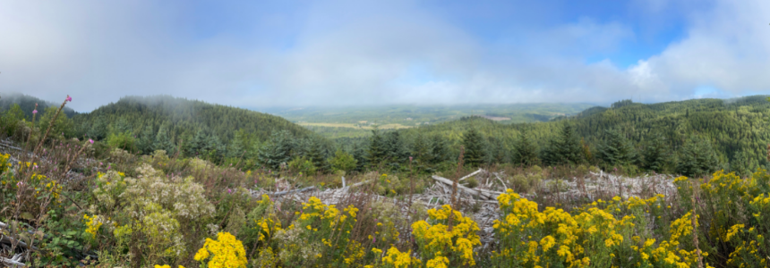
A view from Boneyard Ridge down to the flats at Circle Creek and the Necanicum River.
Over the past several months, North Coast Land Conservancy has been tackling a large but important project: refreshing the boundary markings on all its conserved properties and putting up new ones where needed.
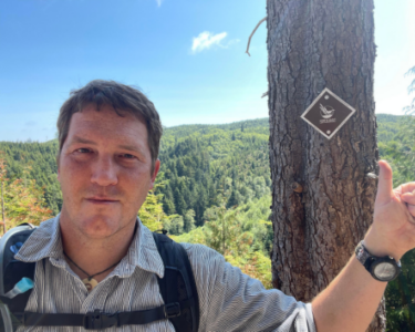
Leading the project is stewardship assistant Morgan Bender-deMoll. By the end of the year, he will have visited approximately 3,200 acres representing NCLC’s fee properties across Clatsop and Tillamook counties—mostly on his own, but occasionally joined by other members of NCLC’s stewardship team.
Morgan was brought on earlier this year for a 10-month contract, primarily to oversee the boundary marking. So far, the task has enabled him to see new places and explore the land in a unique way.
“I’ve been seeing some amazing habitats I would otherwise not have a reason to go to,” he says. “I definitely get to some neat areas.”
However, the task can be challenging as well since it requires physically traveling to the edge of each property. Often when monitoring properties, NCLC’s land stewards and volunteer site stewards can take the path of least resistance that still allows them to take note of any major changes, positive or negative, that could help in identifying new stewardship needs.
But when the job includes reaching a specific point, it means regularly navigating difficult terrain.
“I’m definitely in the weeds on this one,” Morgan says.
While he’s on the land to put up boundary markers, he’s also pulling the occasional invasive plant, making observations and taking notes that can help NCLC with careful stewardship of its properties. This could include information such as what is surrounding each property and any internal and external elements that might pose a threat to the conservation value of NCLC’s habitat reserves.
“We mark our boundaries to get to know our lands better, to make sure we have a good relationship with our neighbors, and we can communicate and can agree on where those lines are,” Stewardship Director Melissa Reich says.
Additionally, the Land Trust Alliance—which represents more than 1,000 land trusts across the U.S.—requires exterior boundaries to be marked if they’re not clearly delineated by natural features, such as a creek or river. NCLC is currently accredited through the LTA Commission and in the process of renewing that status, which is a mark of distinction, showing the organization meets high standards for land conservation.
Having these subtle yet recognizable markers on NCLC’s properties also spreads awareness among neighboring property owners who may not realize they live near conserved land. In fact, the whole community gets a reminder that these beautiful places are preserved for the long-term benefit of plants, wildlife and people.
NCLC has completed boundary marking in the past, but since the markers are put on trees, they must be periodically remounted as the trees grow. Technology has also changed the process of data collection and made it more efficient for NCLC to keep track of where the markers are, what kind of tree they’re on, and other information that will make it easier for the team to find them again in the future, Morgan says. That data, along with other notes and observations, gets fed into ArcGIS Field Maps, the geographic information system (GIS) app NCLC uses.
“Morgan’s not just there to tack up a sign on a tree,” Melissa says. “He’s there to observe what’s happening on the land and notice wildlife and plants and neighboring land-use activities. It also means he’s visiting one of our properties, and each of those visits counts as a monitoring visit, which is another requirement of accreditation.”
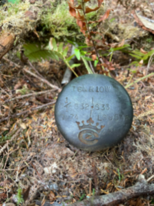
So far, Morgan has happened upon a number of interesting or unexpected sights, including a metal sasquatch someone put up, an abandoned cabin, and remnants of past surveys.
For example, he found this old Crown Zellerbach survey marker from 1974 (left) at the corner of one of NCLC’s forest properties.
“The more time we spend on properties, the better we know them, but also the more issues we tend to find and address,” Morgan says. “When it comes to marking property boundaries, an ounce of prevention really is worth a pound of cure.”
Comments